Ramallah, May 26, 2025: The Colonization & Wall Resistance Commission (CWRC), unveiled alarming news: the Israeli occupying forces have commenced the construction of a colonial road in the western Ramallah area.
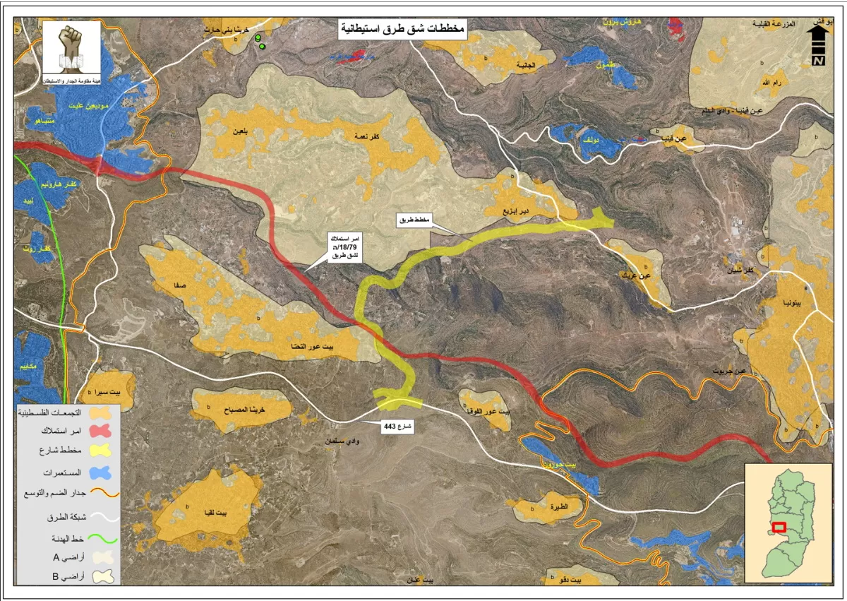
This road is intended to facilitate the movement of colonizers and connect various colonies, all while encroaching upon the rights and livelihoods of Palestinian villages and citizens The head of the Colonization & Wall Resistance Commission (CWRC), Mu’ayyad Shaa’ban declared that the construction of the road, as indicated on the attached map, is based on a military expropriation order issued by the Israeli occupying state in 1979. This order allowed the occupation to seize 2,178 dunams of citizens' land. Mr. Shaa’ban explained that the military order, which authorizes the paving of the road (marked in red on the attached map), begins at the lands of the village of Rafat, adjacent to the so-called “Pisgat Ze'ev” colony. The road extends to the 1949 armistice line, ultimately reaching the so-called “Modi'in Illit” colonial bloc.
Mr. Shaa’ban explained that the military order is strategically designed to establish a vital geographical connection between the so-called “Ofer military site” and the so-called “Givat Ze'ev” colony. This connection will integrate with the colonial Route 443, which is exclusively designated for colonizers and facilitates access to territories occupied in 1948. The primary objective of constructing such road is to reduce travel time for colonizers, traveling from the colonies within the West Bank to these occupied territories. However, this plan also has serious consequences, as it would isolate the Palestinian villages of Kafr Ni'ma and Bil'in from the neighboring villages of Beit Ur al-Fuqa, al-Tahta, and Safa, deepening the division and challenges faced by Palestinian communities.
Mr. Shaa’ban emphasized that just a short distance from the road currently being paved, the Israeli occupying authorities are working on another colonial road plan. This plan seeks to create a connection between the so-called “Talmon” colonial bloc, situated west of Ramallah, and the aforementioned road, highlighted in yellow on the attached map. The goal is to link the colonies located to the west of Ramallah with those northwest of Jerusalem. This development starkly illustrates the deliberate separation and geographical isolation of Palestinian villages, in favor of facilitating the movement of colonizers along these roads.
Mr. Shaa’ban also explained that the aggressive race in the Israeli occupying state to pave and expand colonial roads and seize more Palestinian land is a result of the considerable sums allocated by the occupation government for this purpose.
This year, funding reached NIS 7 billion, aimed at accelerating colonial expansion and attracting more colonizers to live in Palestinian territories. He warned about the grave consequences of this plan on Palestinian lands, emphasizing its impact on citizens' ability to move and access their land, as well as on natural growth and the development of infrastructure in the Palestinian villages and towns in the region.